


![]() The goal of this activity is to enhance undergraduate and graduate student learning in the atmospheric sciences by providing hands-on instrument experience, data analysis, and a practical application of scan strategy design to undergraduate students. While teaching the fundamentals of “flow over mountains” at introductory and advanced levels is important, another goal of this activity is to educate students about field measurements, fundamentals of selection and evaluation of data, and assuring data quality and reliability.
The goal of this activity is to enhance undergraduate and graduate student learning in the atmospheric sciences by providing hands-on instrument experience, data analysis, and a practical application of scan strategy design to undergraduate students. While teaching the fundamentals of “flow over mountains” at introductory and advanced levels is important, another goal of this activity is to educate students about field measurements, fundamentals of selection and evaluation of data, and assuring data quality and reliability.
We request the Rapid Scan Doppler On Wheels radar as part of the National Science Foundation initiative 'NSF Facilities for Education' to be deployed in the Boulder, CO area to observe two snow storms along the foothills during the spring semester 2011. The instrument will be used in the CU undergraduate courses ATOC 1050 (Weather and the Atmosphere), ATOC 4500 (Weather Analysis and Forecasting), ATOC 4720 (Introduction to Atmospheric Dynamics) and the NCSU course MEA511 (Introduction to Meteorological Remote Sensing).
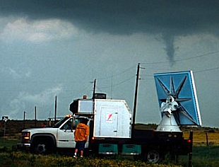 The Rapid Scan Doppler on Wheels radar will be used to show distributions of wind and reflectivity at various heights and distances from the Front Range during snow events. The data will also be used to relate reflectivity observations to the snow amounts measured at the surface, as well as detail the interaction between upstream flow and the mountainous terrain.
This activity is a collaborative effort between Profs. Friedrich and Lundquist of the Dept. of Atmospheric and Oceanic Science (ATOC) at the U. of Colorado (CU) and Prof. Yuter of the Dept. of Marine, Earth, and Atmospheric Sciences (MEAS) at North Carolina State University (NCSU).
Usage of instruments
Radar measurements will be obtained with the help of CU students during university hours (Monday-Friday; 8am – 6pm). During the intensive observation periods (IOPs), 2 CU students at a time will actively be involved in the real-time data collection. Depending on the duration of the event and the availability of students, each group should spend ~2 hours at the radar site. For a 12-hr event, 8 students will have the opportunity to operate the Rapid Scan DOW radars. The radars will run in predefined plan-position indicator (PPI) and range-height indicator (RHI) scan strategies that will be designed by the NCSU students.
Usage of data
Concepts of upslope winter storms, flow over mountains, and radar principles will be introduced to each class prior to the experiment. During the observation period, important details such as the synoptic set-up, unique characteristics of upslope precipitation events, and the interaction between flows and terrain will be discussed at the appropriate level of detail during class. After the experiment students will do a homework assignement dedicated to the radar deployment.