


The rapid-scan radar will scan continuously from the bottom to the top changing between LOWresTALL and HIGHresLOW.
| LOWresTALL | |
 | |
| Purpose | Lower resolution 3-dimensional volume scans will allow to monitor the flow towards the mountains. Lower resolution, tall volume scans will be accomplished when precipitation occurs within 30 km range of the radar. |
Update cycle and temporal resolution | Six elevations will be scanned in 7.5 s, i.e., the entire volume consisting of 10 scans (360deg) will be scanned every 75 s from the bottom to the top. |
| Maximum range and spatial resolution | Ten suits of six elevations will be scanned ranging from 0.5deg - 59.5deg. The distance between the mountains and the radar is about 4-5 km. With the LOWresTALL scans we will reach up to a height of 6 km MSL at a range of 5 km. A pulse length of 100m is chosen in order to achieve a maximum range of 30 km (100 m x 300 pulses = 30 km). |
| Beam Height vs. Range Image: | Show the height of the individual elevation angles ranging from 0.5-59.5deg (each beam is color coded) up to a range of 35 km. The beamwidth is 0.9deg, i.e., 0.5deg elevation angle (black solid lines) ranges from 0.05-1.4deg. The white solid line indicates topography height at 270deg azimuth angle (towards the west). Black, dashed lines indicate that the radar beam is partially (min 50%) or completely blocked by the mountains. The radar location is the Eldorado site south of Boulder. Click image to enlarge. |
| HIGHresLOW | |
 | |
| Purpose | High resolution 3-dimensional volume scans will allow to monitor the interaction between the flow and the mountains. High resolution scans close the surface will be accomplished when precipitation reaches the Front Range. |
Update cycle and temporal resolution | Six elevations will be scanned in 7.5 s, i.e., the entire volume consisting of 10 scans (360deg) will be scanned every 75 s from the bottom to the top. |
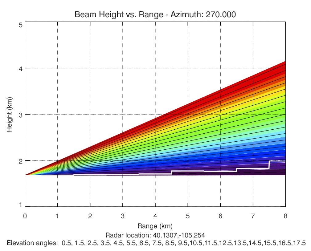
| Maximum range and spatial resolution | Three suits of six elevations will be scanned ranging from 0.5deg - 17.5deg. The distance between the mountains and the radar is about 4-5 km. With the HIGHresLOW scans we will reach up to a height of 3.25 km MSL at a range of 5 km. A pulse length of 25 m is chosen in order to achieve a maximum range of 7.5 km (25 m x 300 pulses = 7.5 km). |
| Beam Height vs. Range Image: | Show the height of the individual elevation angles ranging from 0.5-17.5deg (each beam is color coded) up to a range of 8 km. The beamwidth is 0.9deg, i.e., 0.5deg elevation angle (black solid lines) ranges from 0.05-1.4deg. The white solid line indicates topography height. Black, dashed lines indicate that the radar beam is partially (min 50%) or completely blocked by the mountains. The radar location is the Eldorado site south of Boulder. Click image to enlarge. |